Legible London Research Task
Legible London is a TFL scheme to encourage green modes of transport, such as walking and cycling, whilst also reducing street congestion and improving links with businesses and tourist attractions.


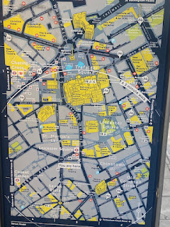


Legible London is designed to target all audiences through a combination of diagrams and clear typography. Legible London's typography features key landmarks and recognisable main streets which are recognisable for everyone, even those who are not native to the area. Other areas not listed within the type are featured in the geographically accurate maps, with one scaled close to the area, in a '5 minute radius' with the larger showing areas further away. This helps the tourist to find specific places when they are in the correct area.
The wayfaring system uses the same colour scheme throughout all of its positions, creating an instantly recognisable source of information that people can trust to follow. Using yellow and white against a dark blue/navy background creates a high contrasting impact. Within the map itself, yellow is also used to highlight key buildings, with line illustrations complimenting this to show recognisable buildings which can be used when wayfaring to give a further sense of where you are. Each post is also titled with its 'area' in yellow, contrasting the rest of the typography to create visual hierarchy which helps ease the flow of information.
TFL's choice of typography is very similar to that used within the underground's wayfaring system that is somewhat at a 'legend' status of recognisability due to how successful the maps are. This decision means users will trust the system due to the feelings of familiarity, as if the signposts have been tried and tested for years.
Whilst the signs are very simple in layout and composition to work for the majority of people with a variety of different physical and visual conditions, there is no way of a blind person using this system as the posts feature no braille or audio option without pre-organisation. Due to the amount of information captured within the diagrams, they may also be visually overwhelming to some people compared to the simplicity of Harry Beck's underground map.
The sign's however are positioned to make these diagrams simpler to follow than the usual map. Instead of following the usual 'north is up' layout following compass orientation, the maps are rotated into the direction you are facing when looking at the post so you do not need to figure out which way you're facing to follow the roads. Sign's are also positioned in high footfall areas such as outside underground stations. This creates a seamless link between transport and walking so at no point do you feel lost, possibly missing the signposts if they're located off to one side.
Overall, I think that this wayfaring system is very effective, having a great impact on a very large audience. I have used these posts many a time without any confusions, sometimes even without realising the impact they have on navigation throughout London if they were not there.
Comments
Post a Comment